Case Study 1: Camp Ripley Sentinel Landscape
Why It Matters
Camp Ripley sits within one of central Minnesota’s most intact working landscapes, where forests, wetlands, rivers, farms, and conservation lands function as a connected system. In a Sentinel Landscape, resilience is more than ecological health. It is operational stability and military readiness. Training schedules, infrastructure reliability, and long-term mission capability all depend on landscapes that can absorb stress without losing function.
Wetlands store floodwater, forests buffer heat, soils regulate infiltration, and intact vegetation reduces erosion. When these systems remain connected, the landscape can withstand drought, extreme heat, flooding, wildfire, and land degradation while continuing to support both ecosystem services and military training operations. In this context, resilience protects natural infrastructure and sustains the environmental conditions that allow Camp Ripley to train, operate, and adapt over time.
Reading the Landscape
If resilience is about the ability to withstand and recover from stress while sustaining military readiness and ecological function, the next question becomes how to measure that capacity on the ground. Rather than asking only where hazards exist, the analysis asked a deeper question: Where is the land most capable of withstanding them?
In this framework, resilience is not defined by exposure alone. It reflects landscape condition, structure, and connectivity, and the ability to absorb disturbance and maintain function over time. The tool evaluates measurable characteristics such as hydrology, vegetation structure, soils, topography, and disturbance patterns, then summarizes them at the parcel scale to produce transparent, repeatable results.
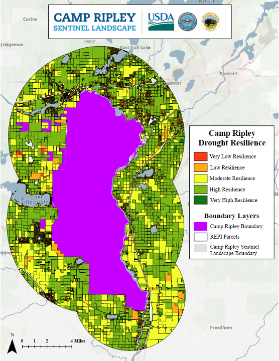
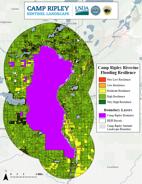
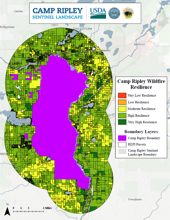
Each parcel within the 3-mile REPI Agreement area was evaluated across five hazards:
- Drought
- Extreme heat
- Riverine flooding
- Wildfire
- Land degradation
Together, these hazards reveal how exposure and landscape condition interact to shape resilience across space.
Key Patterns
Clear spatial patterns emerged across hazards. Parcels near wetland complexes and connected river corridors repeatedly scored higher, reflecting strong hydrologic function and landscape connectivity. Large interior forest blocks also performed consistently well, where intact canopy, lower fragmentation, and stable soils support resistance to drought, extreme heat, and wildfire.
In contrast, lower resilience scores clustered along developed corridors, transportation routes, and urbanizing edges. These areas often showed overlapping pressures, including land conversion, impervious surfaces, drainage alteration, and fragmentation. Agricultural frontiers at forest and prairie edges also appeared more vulnerable where soils are disturbed and vegetative cover is reduced.
Most importantly, resilience was not uniform. Adjacent parcels with similar land cover sometimes scored very differently depending on soil characteristics, proximity to water, topographic position, and disturbance history. That parcel-level variation is what makes the framework actionable. It clarifies where natural systems are already reinforcing mission stability, where vulnerabilities are concentrated, and where targeted protection or restoration could measurably strengthen the landscape. (See maps)
From Maps to Decisions
Each parcel received a 1–5 resilience score for each hazard, representing its relative capacity to absorb stress while maintaining function. Hazard scores were integrated into a composite resilience index to identify parcels that consistently perform well across multiple hazards.
The resulting maps highlight stability, not just exposure. Higher-scoring parcels cluster where ecological systems remain connected and intact. Across Camp Ripley, these areas often share several characteristics:
- Strong hydrologic function, including wetlands and connected riparian corridors
- Stable vegetation structure with lower fragmentation
- Soils that support infiltration and moisture storage
- Fewer indicators of recent disturbance or land conversion
Lower-scoring parcels more often reflect fragmentation, altered drainage, land conversion, or development pressure where stressors overlap.
Practically, the scorecard functions as a decision aid. It identifies resilience anchors worth protecting, restorable parcels where investment could measurably strengthen performance, and edge zones where targeted intervention may reduce future risk.
The parcel-scale framework adapts the DoD Extreme Conditions Assessment Tool concept to a Sentinel Landscape context. For each hazard, multiple geospatial indicators were summarized to parcels using zonal statistics and converted to standardized 1–5 scores. Hazard scores were combined into a composite index using a weighted scoring approach. Processing was performed in Python and GIS, with outputs provided in GIS-ready and tabular formats.
Applications
Camp Ripley’s surrounding lands support more than training operations. They sustain watersheds, wildlife habitat, working farms, forests, and rural communities. By identifying where resilience is strongest and where vulnerabilities concentrate, the scorecard helps partners align protection and restoration with both mission stability and landscape function.
For military planning, parcel-level resilience scoring helps reinforce compatible land use decisions, prioritize buffer investments, and strengthen natural systems that protect training ranges from drought, flooding, wildfire, and land degradation.
For conservation partners, the framework supports easement prioritization, habitat corridor planning, restoration targeting, and funding justification using transparent, science-based metrics. Because the methodology is repeatable and adaptable, it also provides a foundation for long-term climate adaptation planning across the broader Sentinel Landscape.
What This Means for Camp Ripley
Resilience at Camp Ripley is not evenly distributed across the landscape. It is strongest where wetlands, forests, soils, and working lands remain connected and intact. By translating those conditions into parcel-level scores, the Resilience Scorecard makes resilience visible and actionable. It clarifies where natural systems already reinforce mission readiness, where vulnerabilities are emerging, and where strategic protection or restoration can strengthen both military stability and landscape health over time.
Maps
Open a map to view it full-size.


Downloads and supporting files are available in the panel to the right.